Car puzzle tour The victory of the Bourtanger swamp

The route tells the story of peat and heathland reclamation, canalisation, esdorpen, to primeval forests and the Ruiten A that has regained its original watercourse. You will discover secrets, stories and trivia about this special region during the route.

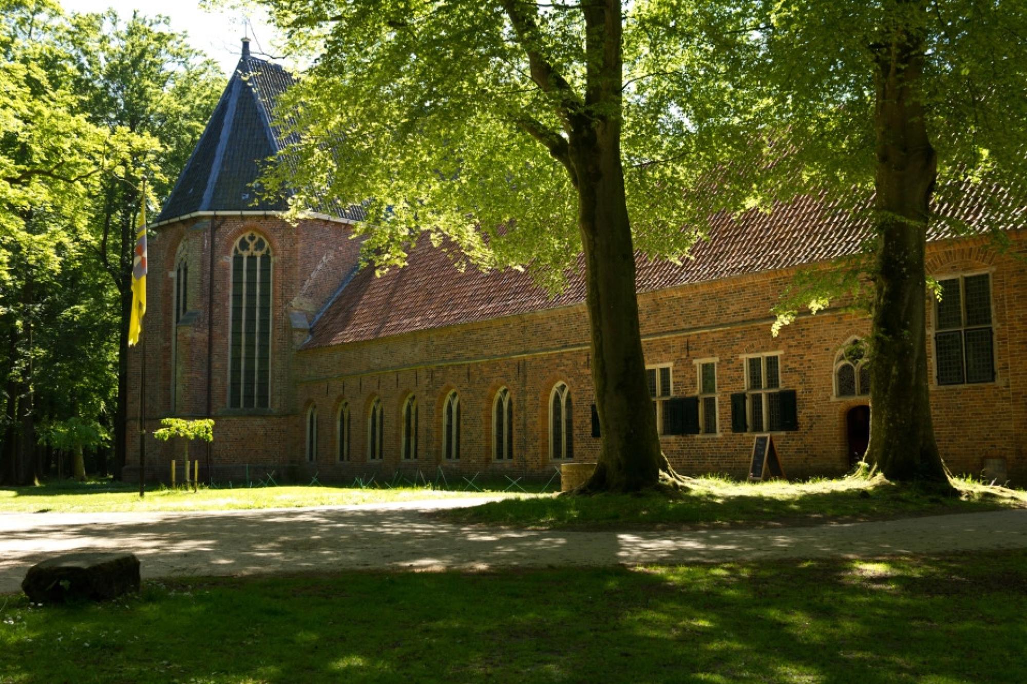
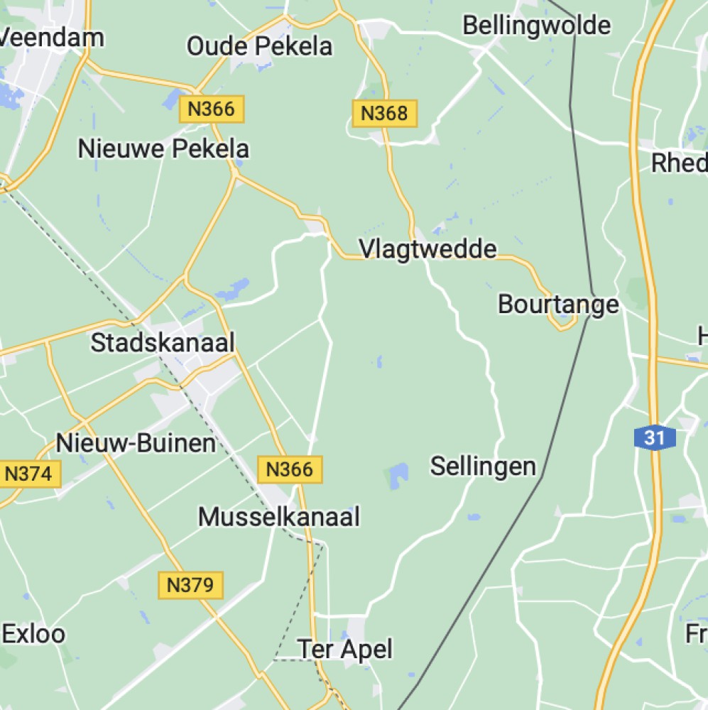
It starts in Stadskanaal, a village that meant a lot in the exploitation of the Drenthe peat for the city of Groningen. Knoal not only has a peat history, but if you look closely, has sights and art that will surprise you immensely. The region was part of an impenetrable bog, one of the largest peat bogs in Western Europe. Westerwolde is sometimes called the Netherlands' best-kept secret. With this route, we lift a few tips of the veil. In the process, the area has a rich history with many historical stories.

A varied route that shows both urban and rural areas. Come and discover it.

ROUTE RIJDEN MET ROUTEBOEK OP SCHOOT, OF RIJDEN MET DE ROUTE-APP?

De route 'Westerwolde: Overwinning van het Bourtange moeras' kun je rijden 'met routeboek op schoot', óf met de LocalGroningen-route-app. De route met de app is is gelijk aan de route met het routeboek. In het routeboek is de routebeschrijving met km-aanduiding en richtingpijltjes. Er zijn enkele spel- en puzzelvellen toegevoegd; altijd leuk voor kinderen op de achterbank.

De LocalGroningen-route-app biedt de route met behulp van navigatie. Informatie over de punten wordt geboden in korte tekstblokjes én in diverse audio-fragmenten. Je kunt kiezen om wel of niet mee te doen met quiz-vragen. Ga naar de APP-STORE, of naar GOOGLE-PLAY, om direct de LocalGroningen app te installeren.

Maak hieronder je keuze: met routeboek, of met app.

Basispakket met routeboek

Bij aankoop van het basispakket ontvang je het volgende:

  • gedetailleerde routebeschrijving
  • beschrijving bij bijzondere punten
  • autobingo en puzzels voor de kids

(Prijs basispakket is per auto)

€22
Book now
Basispakket app

Bij aankoop van de route, ontvang je het volgende in de app:

  • een gedetailleerde routebeschrijving
  • informatie bij tal van punten onderweg
  • audiofragmenten
  • puzzelvragen
  • tips voor wandelingen, uitstapjes en terrasjes.
€18
Book now
## Route information

## Route information

  • Start location: Camping De Kapschuur, Stadskanaal
  • End location: Gasterij Natuurlijk Smeerling
  • Length: approx. 50 or 65 km (incl. optional suggestions along the way)
  • Duration: approx. 3.5 to 4 hours, depending on the number of trips and stops
  • Information with text in the route book, or:
  • via audio clips and text blocks in the app
  • Along the way: tips for a terrace, nice gallery, museum, walking route, etc.

(Opening hours of terraces, museums, visitor centres differ).

## How does it work?

## How does it work?

  • Choose driving with route book on your lap, or driving with the LocalGroningen route app
  • Then choose your package, your route, and date
  • If you will ride with the app, [page - 182] (click here) for information about riding with the app
  • After your order, you will receive a confirmation e-mail with a link.
  • Use the link to download the first information
  • Have you ordered riding 'with route book'? Pick up the route book on the booked date, at the start location.

## Some responses from riders

"We discovered many new things with the children.

"We found it a fun, varied route, in which we first saw a lot of Stadskanaal and then a lot of the countryside around it."

"What a fun surprising and above all varied route this was. The weather was beautiful too! Villages and nature interspersed, nice information and what a beautiful area the forests in Ter Apel, Sellingen and Smeerling. Really worthwhile, and then now everything was still bare, you have to imagine what it will look like later......beautiful!"

## Some responses from riders

MORE INFORMATION, OR WANT TO BOOK FOR A GROUP?

Contact